Written by Rick Kirchhof – NG5V on 09 September 2015
Texas has strange, unpredictable and often violent weather. Rainfall rates can be much higher here than in other parts of the country. Many people are new the to the Central Texas area and have never seen rain falling so hard that you can’t see the front end of the hood on your car. Rains like this can cause road and bridge flooding, creating deadly risks to people not expecting their car may get washed away. Lightning, hail and high winds all present special risks to people and property. The National Weather Service has large amounts of data available to it but they don’t have eyes in the field in most cases. Trained weather observers, amateur radio operators and new automated systems like the Austin Flood Early Warning System (FEWS) add to situational awareness at the NWS. However, more information is needed.
Police, Fire, EMS, Water and Street/bridge teams all report information upward within their organization. Usually this info is only for that team does not travel further or become notices to the public. CERT and other volunteer groups all have additional information but not a quick way to submit it for action. Amateur radio operators are different. Where ever you may be, if you have info about serious or dangerous conditions, hams can get that to someone and drive actions by general reports, or in a special Weather Net.
Weather nets, held on a wide coverage local repeater, are an Austin tradition going back decades. Hams can provide quality, up to the minute info about what is actually happening in the field. Most of the information flows from the hams, to the weather net, and onward to the NWS or other served agencies who monitor our on-air nets. Sometimes, questions come to the weather net control about conditions in a given area. In this case, the NCS may ask if anyone is observing near a specific locaiton.
TV and radio stations frequently monitor weather nets to see what events present special risk to the public. Always assume that your transmission to the weather net will be monitored. These are frequently repeated by local weathercasters within minutes of their occurance on the net. Reports must be accurate, specific and include the location and time of the weather event. Do not use the word Tornado unless you are certain that a funnel cloud is in contact with the ground and debris is visible. Skywarn training is invaluable for obtaining skills you need to accurately observe and report weather events.
Here is proof, read about the unprecedented flooding along Onion Creek
October 2013 is one for the record books. There were a number of rain daiys during the month. Heavy rains fell in the Southern and Eastern parts of Travis county on 10/13 and again overnight into Halloween. You have heard for years the SKYWARN stories about weather in this part of Texas being a series of droughts interrupted by floods.
I had previously listed a number of links for weather and stream/river info elsewhere on this site. One of the best of these is the group of USGS river and stream flow gauges. The list of Texas gauges, grouped by county is found here. This site also has a new mobile device version under development. Read the Mobile Site Tutorial Try it (http://m.waterdata.usgs.gov) from your mobile device! All graphhics in this article are courtesy of the USGS.
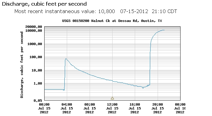
Of particular interest is the RATE at which these streams can rise and flood. One night in July, 2012, tiny Walnut creek exploded after multiple rain storms. The result is a threat to everyone downstream. Flows at this rate can mean the end of your life if you slip into the water.

The chart above has no real scale since few people think of river flow in cubic feet/sec. It takes on new meaning when you realize the water flow that flooded the shores of LadyBird Lake after the rainfall was only a little more flow than the Walnut Creek flood.

Both of these are truly outclassed by the historic flooding that occurred along Onion Creek the morning of 10/31/2013. Most of the creeks and streams in the county are either dry or just enough to let your dog play a bit. They can turn into killers like Onion Creek did during the flood.

The chart also shows the rain event from earlier in the month. Between these times, Onion Creek, like many of the nearby creeks is either totally dry or something you can find enough rocks to step across with dry shoes. The lesson here is: Creeks can and do rise very quickly. Buildings, equipment, pets and people near them at that time are in grave danger. Many Central Texas residents are new to the area.
Try to share your understanding of water safety and explain the true meaning of “Turn Around, Don’t Drown”.
